There are 179 traffic cameras inside Philadelphia's city limits that PennDOT publishes for anyone to look at. There is a camera on the Franklin Institute roof pointed down the Parkway, two more on the Liberty Bell, six around Rittenhouse Square, seven at the Italian Market, and a FOX 29 camera that has been watching Center City from the United Way building for years. None of this is secret. All of it was scattered across a dozen websites, each with its own menu, its own player and its own idea of what a map is.
So I put them on one screen. Philly Street Cam is live at phillystreetcam.org. It is free, it needs no account, and I built it at my own expense. This piece is about what it does, what it deliberately does not do, and why I think a city should be able to see what its public cameras see.
What you get
Two views of the same 208 cameras. The Wall is every camera as a small live window, so you can read the whole city at once: pick a size, search a street or a neighborhood, filter by type. The Map puts those same windows on a vector map of Philadelphia, each one tied by a thin line to the exact spot the camera stands. Click anything and you get the big view, what the camera covers, who runs it, and a link straight back to the owner's own page.

Every source is one its owner publishes on purpose. PennDOT's 511PA network supplies the traffic stills. EarthCam and FOX 29 supply skyline video that plays inside the viewer. The AtTheShore cameras around Rittenhouse, Headhouse Square and 9th Street are linked, not copied. Windy's network fills in previews where an operator allows it. The site drops anything that turns out to be a copy of a camera already on the wall, and I did not include five things I found: two dead bridge cameras, a dead zoo camera, an unlicensed rebroadcast of the airport, and a set of streams that show people in crisis on Kensington Avenue. That last one is the point of the whole project, so it gets its own section below.
How a still camera gets motion
PennDOT's pictures change about once a minute, and the real video is locked to PennDOT's own player, which is their right. I wanted motion anyway, so I built a recorder.
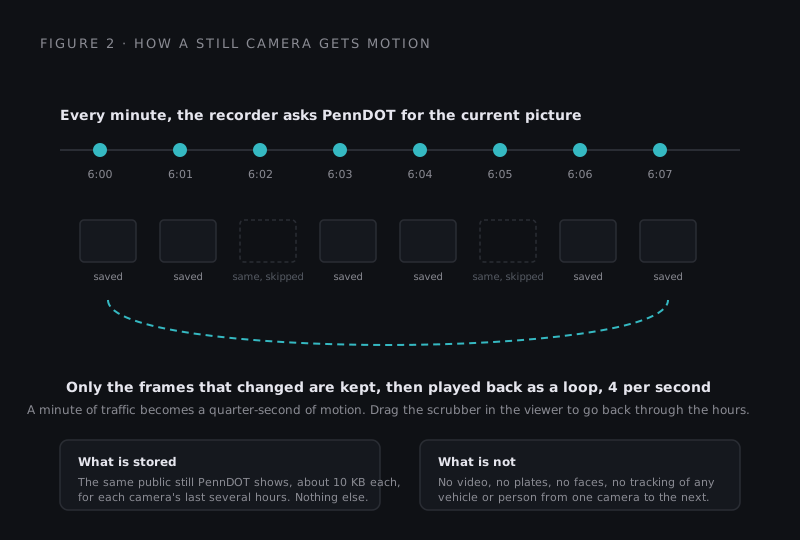
Every minute it asks each camera for its current picture. If the picture has not changed, it is thrown away. If it has, it is kept, about ten kilobytes each, for the camera's last several hours. The wall then plays those frames as a loop at four per second, so an hour of a highway becomes fifteen seconds of traffic breathing. In the big viewer there is a scrubber: drag it back and you can see what the Schuylkill looked like at 5:40 instead of 6:40. Only the windows actually on your screen load anything, which is why the whole thing runs comfortably on a phone.
What it will never do
Here is where I have to be plain. The same pictures that let a neighbor check a route could, in the wrong hands, be used to follow a specific car across the city. I will not build that, and I will not let this site become it. The wall shows no private cameras, nothing behind a login, nothing an owner did not publish for the public. It does not read plates. It does not pick out faces. It does not connect one camera's view to the next to track anyone. When I write about what the cameras see, I will count things, not people: how many trucks, how long a lane stays blocked, which corner floods. Those numbers help planners and reporters. Following a person helps no one I want to help.
I started this because I believe public safety, privacy and accountability should strengthen one another. Residents deserve understandable information about technologies that may affect their daily lives, civil liberties, personal safety and ability to earn a living. The cameras are already there. The least we can do is make what they show legible to the people being shown.
Where it goes next
The wall is the foundation. The longer-term goal is verified research into how camera systems and related data in Philadelphia are collected, accessed, shared, retained and governed, written up so that an ordinary resident can ask an informed question at a council meeting. AI will help with the research and the organizing; a human reads everything before it is published; sourcing is shown; corrections are open. The guiding commitments are lawful access, clear sourcing, accurate descriptions, appropriate privacy protections and an open correction process.
Three doors are open right now. I have asked PennDOT for access to its developer data feed, which is the sanctioned route to real video. I have asked the people who run the Rittenhouse and Italian Market cameras for permission to show their players directly on the wall. And a registration gate with abuse monitoring is built and waiting, so if the site ever draws the wrong kind of attention, it can ask people to sign in and I can see who is doing what.
The money part
I pay for this myself today: the hosting, the recorder, the time. It stays free to look at. If it is useful to you, there are three ways it can pay for itself without ever charging a neighbor to see a public camera. A newsroom, insurer or law office that wants the archive at full depth, or an alert when a specific intersection floods or clears, can sponsor that feature. A developer or planner who wants the counts, not the pictures, can license a monthly data report. And if you want a wall like this for your own town, or any other product built with the same care, that is what the studio does; the commission tiers are on the build page. Contributions of expertise, reliable information, permitted data access and financial support toward clearly described needs are welcome, and I will publish what each one paid for.
Go look at your block. If a camera is missing, wrong, or should not be there, tell me, and I will fix it in the open.